online edition
Instructions:
You can plot any point from the Gold Bug's SiteFinder database onto Google Maps.Fill in the fields above and click "Search SiteFinder"
If your query finds too many locations, it will only plot up to the limit set by "Query limit".
If your browser doesn't support Google Maps, you can still view entries in the database by choosing "List results in a table" from the popup menu.
Some locations in the database don't have latitude/longitude information. If you choose "Show both map and table" from the popup menu you will see a list of locations below the Google Map. All locations, including those with no lat/long information, will appear in the table, even though they are not plotted on the map.
 The SiteFinder online edition plots locations against a current map of the United States.
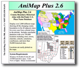
The AniMap Plus software for Windows connects the SiteFinder database with an
historical U.S. county boundary atlas so you can track locations as the county boundaries change over time. Knowing in which
county a site is located is invaluable for genealogical and historical research. © 2006 The Gold Bug
(5/17/2006)
The SiteFinder online edition plots locations against a current map of the United States.
The AniMap Plus software for Windows connects the SiteFinder database with an
historical U.S. county boundary atlas so you can track locations as the county boundaries change over time. Knowing in which
county a site is located is invaluable for genealogical and historical research. © 2006 The Gold Bug
(5/17/2006)